Surface Ozone
Understanding the sensitivity of surface ozone pollution to precursor emissions of NOx and VOCs
1. A space-based indicator of surface ozone production
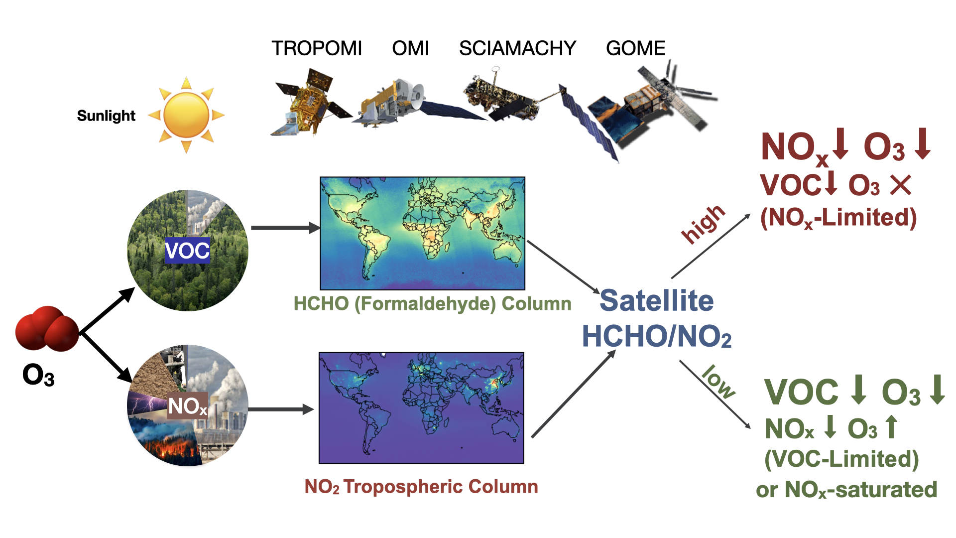
Ozone at ground level is a harmful air pollutant, and it is the main ingredient of the photochemical smog. In the U.S., 90 million people live in counties with O3 air quality above the EPA standard in 2021. We bridge satellite observations of NO2 and formaldehyde (HCHO, a proxy for VOCs) with a global chemical transport model (GEOS-Chem) and ground-based observations to identify the sensitivity of O3 production to precursor emissions over global source regions. We evaluate the uncertainties of using satellite-based ratio of HCHO to NO2 to identify the O3 production regimes (Jin et al., 2017).
We find that O3 production is making the transition towards NOx-limited regimes in U.S. urban areas and Europe as a result of NOx emission control (Jin et al., 2017). The regime transition has led to a reversal of the O3 weekend effect and decreasing urban-rural gradient of O3 (Jin et al., 2020). In China, the O3 production regime is increasingly VOC-limited before 2013, but has become more NOx-limited in recent years (Jin et al., 2015 and 2017). Our work shows the promise of using satellite observations to assess which emission reductions to focus to maximize the cost-effectiveness of pollution controls. We contributed to a technical guidance document for incorporating satellite data into State Implementation Plans (Jin et al., 2018), which are part of the process by which nonattainment areas demonstrate how they will achieve compliance with the National Ambient Air Quality Standards.
Funding Support: NASA Aura Science Team and ACMAP (Atmospheric Composition, Modeling and Analysis Program), NASA Earth and Space Science Fellowship, NASA Health and Air Quality Applied Science Team

Related Papers:
Jin, X., A. M. Fiore, K. F. Boersma, I. De Smedt, L. C. Valin. Inferring changes in summertime surface ozone-NOx-VOC chemistry over U.S. urban areas from two decades of satellite and ground-based observations (2020), Environmental Science & Technology, doi:10.1088/1748-9326/ab2dcb
Jin, X., A. M. Fiore, L. T. Murray, L. C. Valin, L. N. Lamsal, B. N. Duncan, K. F. Boersma, I. De Smedt, G. Gonzalez Abad, K. Chance, G. S. Tonnesen (2017). Evaluating a space-based indicator of surface ozone-NOx-VOC sensitivity over mid-latitude source regions and application to decadal trends, Journal of Geophysical Research: Atmospheres , 122, 10439 – 10461, doi: 10.1002/2017JD026720 (reported by NASA Earth Science, NASA Earth Observatory, LDEO news etc.)
Jin, X., T. A. Holloway (2015). Spatial and temporal variability of ozone sensitivity over China observed from the Ozone Monitoring Instrument. Journal of Geophysical Research Atmospheres , 120(14), 7229–7246, doi: 10.1002/2015JD023250
Jin, X., A. M. Fiore, M. Geigert., (2018) Using satellite observed formaldehyde (HCHO) and nitrogen dioxide (NO2) as an indicator of ozone sensitivity in a State Implementation Plan (SIP), doi:10.7916/D8M34C7V
Anenberg, S., Bindl, M., Brauer, M., Castillo, J., Cavalieri, S., Duncan, B., Fiore, A., Fuller, R., Goldberg, D., Henze, D., Hess, J., Holloway, T., James, P., Jin, X., Kheirbek, I., Kinney, P., Liu, Y., Mohegh, A., Patz, J., Jimenez, M., Roy, A., Tong, D., Walker, K., Watts, N., West, J. (2020). Using Satellites to Track Indicators of Global Air Pollution and Climate Change Impacts: Lessons Learned From a NASA‐Supported Science‐Stakeholder Collaborative, GeoHealth, 4(7), doi: 10.1029/2020gh000270.
Naimark, J.G., Fiore, A.M.,Jin, X. , Wang, Y., Klovenski, E., Braneon, C., (2021). Evaluating Drought Responses of Surface Ozone Precursor Proxies: Variations with Land Cover Type, Precipitation, and Temperature. Geophysical Research Letters, 48, e2020GL091520, doi:10.1029/2020GL091520